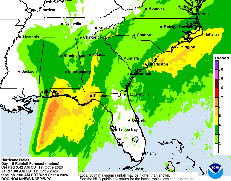
Image from NOAA.gov - This map shows projected rainfall amounts from Hurricane Isaias, which is expected to make landfall Friday night and could bring significant rain to or area Saturday.
Warren County residents could face damaging winds, flooding and widespread power outages this weekend as Hurricane Isaias moves inland, prompting local emergency officials to prepare for the possibility of opening an emergency operations center and public shelter.
Warren County Emergency Management Director Jason Hillis said the county could begin experiencing the effects of the hurricane as early as 4 a.m. Saturday, with sustained winds of 30 to 40 mph and gusts potentially exceeding 60 mph.
A wind advisory is in effect through 1 a.m. Sunday, while a flash flood watch extends from 1 a.m. Saturday through 1 a.m. Monday, according to Hillis. There is also a slight possibility of an isolated tornado, although Hillis said that threat is considered unlikely.
"Warren County Emergency Management is monitoring the situation as it develops and is prepared to activate the Operations Center and Emergency Shelter if needed," Hillis said in an email to the Main Street Journal on Friday.
Hillis provided the update after participating in a briefing with state emergency management officials concerning the approaching storm.
As of 10 a.m. Friday, the National Hurricane Center reported Isaias had strengthened into a Category 3 hurricane with maximum sustained winds of 120 mph. The storm was located approximately 195 miles south of Pensacola, Florida, moving north-northeast at 16 mph. Forecasters expected the hurricane's center to reach the western Florida Panhandle coast Friday evening.
Although Isaias is expected to weaken as it moves inland, its remnants could bring significant rainfall and strong winds to Middle Tennessee throughout the weekend.
The National Weather Service in Nashville is forecasting 1 to 3 inches of rainfall across Middle Tennessee, with the heaviest precipitation expected Saturday and Saturday night. Forecasters have warned that excessive rainfall could cause flooding along creeks, streams, low-lying areas and roads with poor drainage.
Strong winds could also bring down tree limbs and power lines, potentially leaving residents without electricity.
Hillis said Warren County Emergency Management is prepared to activate its emergency shelter if conditions warrant. The shelter is located inside Three Star Mall at 1410 Sparta Street in McMinnville.
The shelter is not currently being announced as open, but officials are prepared to make it available if necessary.
"In order to respect the needs of all citizens, no pets are allowed at the Emergency Shelter," Hillis said.
Residents are encouraged to take precautions before the storm arrives, including securing outdoor furniture and other loose objects, charging cellphones and portable battery packs and making sure flashlights and emergency supplies are readily available.
Households should also have drinking water, nonperishable food, necessary medications and other essential supplies in case severe weather interrupts electrical service or makes travel difficult.
Motorists should avoid flooded roadways and never attempt to drive through standing or moving floodwater. Residents living near streams, creeks or other flood-prone locations should pay particular attention to changing conditions.
Hillis urged residents to remain aware of the weather throughout the weekend and to take advantage of the county's emergency notification resources.
"Please stay weather aware," Hillis said.
Residents can follow the Warren County TN Emergency Management Facebook page for local updates. They can also register to receive emergency text alerts by visiting warrencountytn.gov and selecting the Emergency Management tab at the top of the homepage.
Weather conditions and forecasts may change as the storm moves inland, and residents are encouraged to monitor official weather information and local emergency management announcements throughout the weekend.
Share this article
The link has been copied!
Members Discussion
Your link has expired. Please request a new one.
Your link has expired. Please request a new one.
Your link has expired. Please request a new one.
Great! You've successfully signed up.
Great! You've successfully signed up.
Welcome back! You've successfully signed in.
Success! You now have access to additional content.